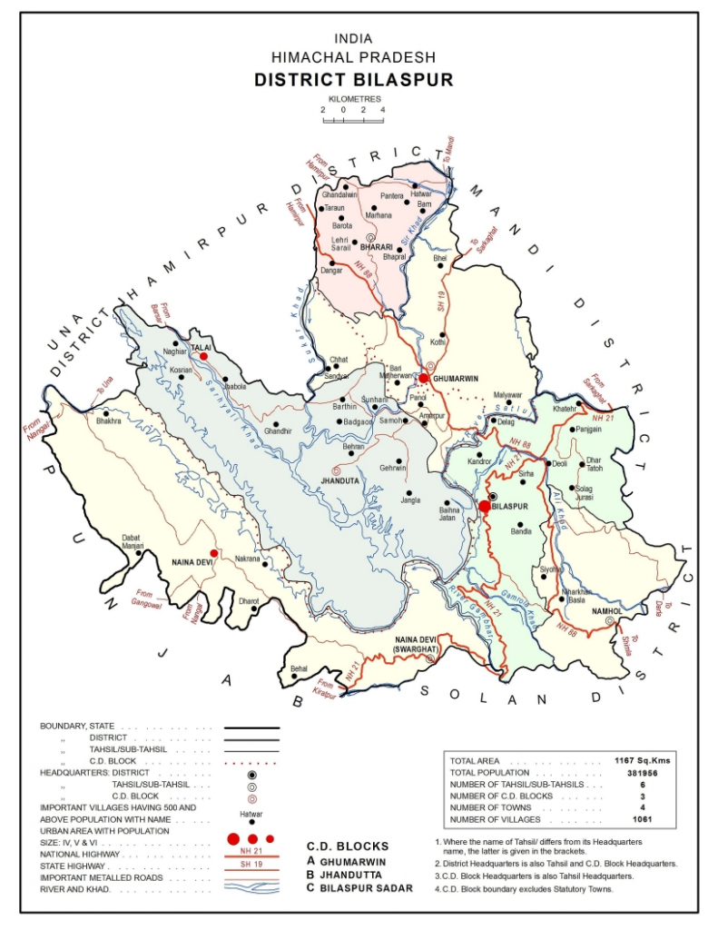
BILASPUR
Total area -: 1,167 sq. Kilometer
Language Spoken: BILASPURI (KAHKURI), HINDI, PUNJABI ETC.

There are seven main ranges of hills. Your Attractive Heading
- Naina Devi Dhar: Kot Kehlur and ‘Fatehpur Fort’ are located on this range.
- Kot Dhar: The well known forts of Bachhretu, Basiah, Naun or Shiwala Bachhretu Kot and Dagoga Malhot are located on this hill. The highest peak ‘Kakrer’ has an altitude of 1,430 metres.
- Jhanjiar Dhar: Seer Khad divides this range into two parts; Southern part known as Badol, and Northern as Jhanjiar. The Jhanjiar is the peak range at about 1,100 meters above mean sea level. There is famous temples of ‘Devi Badoli and ‘Guga Gherwin’ located in the southern range.
- Tuin Dhar: The highest point is the ‘Sariun Peak’ at about 1,350 meters of altitude. The fort of Sariun, Naurangarh, Temple of ‘Peer Bhiuanu’, ‘Haramba Devi’, ‘Tiun fort’ and ‘Sidh Gurunath’ are located on this hill.
5. Bahadurpur Dhar : Ali Khad divides this hill into two parts, Northern known as Tatoh and southern as Bahadurpur. The summer adobe of RAJA BIJAI CHAND.
6. Ratanpur Hill: It was from this fort that General Ochterlony inflict defeat on Amar Singh Thapa, the Gurkha Leader.
7.Bandla Hill:17 Km in lenght. Its highest peak has an altitude of 1375 mts from sea level
There are three famous valleys in Bilaspur Distt.
The Satluj Valley: The Satluj flows for about 90 Km within the distt., stating from ‘Kasol’ hamlet, where the river enters and running up to village ‘Naila’, where it leaves the district.
The Chaunto Valley: Stretching nearly 13 Km near Bhakhra dam, is flat and has very fertile soil.
The Danwin Valley: It is located between Bahadurpur and the Bandla hills and is about 10 Km in length and 5 Km in width.
RIVER SYSTEM in BILASPUR
Bilaspur district’s main river is the Satluj. After flowing through Kinnaur, Solan and Mandi districts, it enters Bilaspur at village Kasol and leaves the district at village Naila, in pargana Kot Kahlur.
It was the river over which the treaty between the English and Maharaja Ranjit Singh of the Sikhs Kingdom was signed in 1809.
Several foreign travelers, William Moorcraft (1820 A.D.), Baron Charles Hugel, a German (1835 A.D.) and G.T. Vigne (1838-39) have left very interesting accounts of the river satluj.
Ali Stream: It rises near village ‘Mangu Giyana’ in Tehsil Arki of Solan district and enters Bilaspur at village ‘Kothi Harrar’ and ‘Manothi’. It joins Satluj at a point known as ‘Beri Ghat’.
Ghambar Khad: It is a tributary of Satluj. It rises below Tara Devi in the Shimla Hill, enters Bilaspur at Village ‘Neri’ of Pargana Ratanpur and finally outflows into Satluj at village ‘Dagran’.
Seer Khad: It is the largest tributary of the Satluj, which rises in Mandi district. Two small khads known as Sukar and Saryali rising in Hamirpur district join this Khad at village ‘Balgar’. It enters Bilaspur district at village Hatwar and joins the Satluj at village ‘Seri’.
JAGAT KHANA TANK AND TANK AT SWARGHAT have been constructed by RAJA HIRA CHAND in 1874.
TANK OF TOBA SANGHWANA was constructed by Raja Bijai Chand.
